


Bar to Niksic: Montenegro Week 3
Mountain passes, heatwave, springs, tunnels, friendly locals and turtles Over the past week, we have cycled from the southern coast in Bar to northern mountains in Danilovgrad and now in Nikšić. We have covered over 140 km in 5 days with over 2800 metres of climbing. Till date in Montenegro, we have cycled over … Continue reading Bar to Niksic: Montenegro Week 3

Kotor to Bar: Montenegro Week 2
Crowded beaches, scary coastal highways, beach camping, bureks and humidity After a relaxing week in Kotor, we have cycled under 70 km over 3 days following the coastline of Montenegro from Budva to Bar. Unlike Croatia, we have slowed down our pace and keen to avoid finishing our time here too quickly. This chapter is … Continue reading Kotor to Bar: Montenegro Week 2
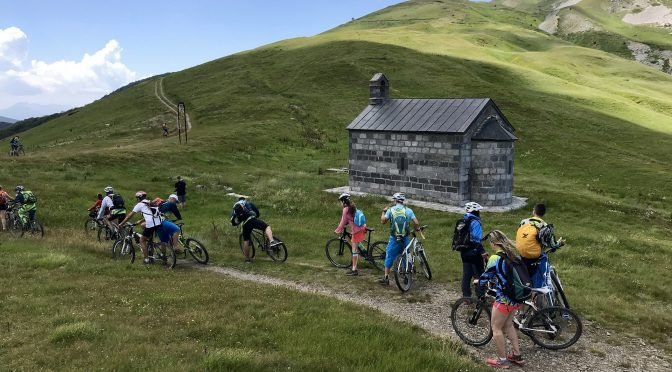
Bulgarian Bikers Again in Northern Montenegro
Translated using Google Translate. We apologize for grammatical errors. We have already written about a large group of Bulgarian mountain bikers who fell in love with Bjelasica, Komovi and Prokletije and who regularly spend their holidays on these mountains. This year they selected our center for their base and seven days they were exploring for them … Continue reading Bulgarian Bikers Again in Northern Montenegro

Markus Pekoll: Montenegro (Video)
We are finally on our way to Montenegro, a real trip into the unknown. Each one of us seems to be lost in their own thoughts as we drive along the stunning coastline, our eyes transfixed on the shimmering blue of the ocean. We have great plans and expectations and still we feel like our … Continue reading Markus Pekoll: Montenegro (Video)

Gračanica: Family Farm – Slope of the Fireflies
Slope of the fireflies is an initiative of family Vugdelic. They are a city-born family of highly educated and well travelled persons, who decided to live a life that is more in tune with the nature, as well as preserve local values, traditions, natural heritage and share them with the world. The farm is located … Continue reading Gračanica: Family Farm – Slope of the Fireflies

OpenStreet maps for Garmin devices
We have already written about our work on a comprehensive online maps update (OSM and Google Maps), especially when it comes to the northeastern Montenegro region, and now we are going one step further. We’ve created maps for Garmin GPS devices based on our mapping and data from OSM databases that, unlike the maps you … Continue reading OpenStreet maps for Garmin devices

Our Work On Open Street Maps
Three months ago we have initiated a comprehensive work on OSM (Wikipedia) online map which is used by many navigation and orientation applications. Where Montenegro is concerned, this map has been completely useless, as it contained very little data, and the data that was entered was mainly related to urban areas. We started from the … Continue reading Our Work On Open Street Maps

Balj and Pisevo
Balj and Piševo, mountains that stretch over Andrijevica villages Seoce and Gracanica, are very interesting when it comes to mountain biking, and this route is the missing link to complete a network of Andrijevca biking trails. The route is rich with beautiful vantage points of the valley of Lim, Andrijevica, Komovi and Zeletin and on … Continue reading Balj and Pisevo

CS3: Crni vrh – Veliđe
We recommend this route for all seasons, though we liked it most in autumn, during the Indian summer, when the colors go crazy and leaves rustles underfoot, when shephers return from summer pastures the village meadows become noisy with the sound of sheep, when brandy making season starts and orchards are bowed under the weight … Continue reading CS3: Crni vrh – Veliđe

Circle Around Komovi
In addition to the already well-known paths that lead to the three main and most attractive peaks of Komovi – Vasojevićki (2461m), Kučki (2487m) and Ljevorečki Kom (2463m), in the immediate vicinity of this magical mountain there are many hiking trails that are also exciting and beautiful but are somewhat less known or completely unknown … Continue reading Circle Around Komovi